Painted Desert

Painted Desert

Saturday, July 31, 2010

A Saturday update


Here is a well-preserved bear footprint in the mud at one of our sites. Big, huh?

A couple weeks ago we made our third and final trip to the landslide. Largely it was the same old thing -- digging holes, and installing instruments, in beautiful natural surroundings. So I don't have that many pictures to show; you've already seen the slide, and red mountain, and the Matterhorn. But here's me in a hole I was digging:


Our supervisor removing equipment from a pole as a thunderstorm moved in:


We got to explore a little around the San Juan Mountains in the area where we were working.


This is a rock glacier in American Basin, and me. A rock glacier is a bunch of rocks frozen together.


Marmots. You could get quite close to the marmots before they would run away. I have learned, by the way, since my last post with a marmot, that marmots and groundhogs are essentially the same thing, but they are called marmots in the west.


This basin was at 12,000 feet (heck, probably still is) and from there I climbed most of the way up a trail to the peak of one of Colorado's 14ers--that is, a peak over 14,000 feet--called Handies Peak. The trail was very gentle and smooth but the altitude had a big effect. I was dizzy and tingling and had to go very slow. I made it within a few hundred feet of the top, but couldn't go all the way up as we didn't have enough time.


Here is a view from near the top, of mountains beyond mountains in the San Juans.


On the way back to Golden, this bag of chips was purchased at a tourist trap on Monarch Pass, at 12,000 feet or so. It was packaged at a lower elevation and the air inside had expanded a great deal.

Here in Golden, I have been doing many things, including making friends. The magic of the internet makes this easier. There is a site called Meetup.com, where you can search your area for groups of people with the same interests. So I have been dancing, hiking, and done photography excursions with people.


A rainbow confirms the existence of gold beneath Denver. Who needs geology?


Some new acquaintances on the photography hike. (The rainbow wasn't planned, though I claimed it was.)


Me above Golden on a hike. I have to stop sliding my hat off onto my back for pictures, it makes me look like a hunchback.


The clouds outside my house one night. This doesn't have anything to do with anything, it's just pretty.


A guy on an old-time bicycle at the Buffalo Bill Days parade. See you next time!

Saturday, July 17, 2010

The Great Sand Dunes, and friends

Wow, how long ago did I go to this place? I have been truly busy since I got back... I guess it must have been about three weeks ago. Wow. Well, here you are.


Great Sand Dunes National park, in south-central Colorado, is pretty fantastic. I would say it's worth a trip, but that's rather vague; for one thing, it's in the middle of nowhere, lots of nowhere, in which I felt quite close to falling asleep at the wheel and meeting my doom on a very long, straight road from nowhere to nowhere. But if you happen to be near the middle of nowhere already, it's definitely worth a visit.

It's not that large... the dunes look like, well, just some sand that made a little pile against the mountains. The tallest is maybe 700 feet. Looking at them is cool, but what I probably can't accurately convey here is just how cool it is to walk around on them. Before I try, some pictures:


The above looks like a cross between a black & white and a color shot, but it's just because the angle of light is so low on the dune in the foreground.


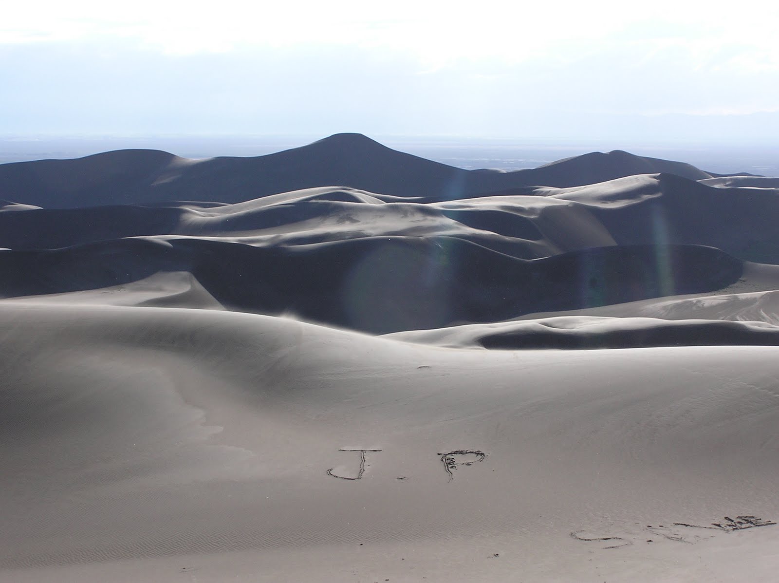
When I crested High Dune, which visitors all like to hike up to, I found this on the other side. Someone had saved me the trouble of writing my initials in the sand... if I'd wanted to.


Walking around in the dunes was fascinating to me as a geologist (which I am now!) because I could see, being formed in front of me, the types of structures I'd only seen before in rocks formed from ancient deserts.


The lines here, which cut each other off, mark the shifting direction of the dominant winds. Some of the sand is made of magnetite, which is both darker and heavier... wind and water "sort" sand into different sizes or weights, since, for instance, a wind of a given speed might be able to pick up quartz grains but not magnetite, so the two get separated. This separation allows us to see the lines above... I would say the lines are perpendicular to the dominant wind direction at the time they were deposited, but that would only hold for really straight-edged dunes. These dunes have wavy crests, which creates curved lines like you see above. It's a function of the amount of sand available and how much the wind shifts around.


The dunes look yellow in some pictures, but really they're brown. Sand is fascinating to look at up close. From the size, color, roundedness, and sorting (are they all one size, or many sizes?) of the grains, you can tell how far the sand has traveled and how long it's been sand. Quartz is very tough. If sand has been around a long enough time, it will be all quartz, all the other grains having broken down. This sand is only part quartz, and in fact, it was rock relatively recently.

I went for two walks on the dunes: one the evening I arrived, and one the next morning. In the evening, a good wind kicked up, which made things very interesting. I was wearing shorts, for one, and my calves were being absolutely sandblasted, which was not so much a wholly painful sensation as a very uncomfortable one. Maybe like having bandaids ripped off the entire surface of my calves, constantly. The sand also hissed, and rode over the surfaces of the dunes like mist. It was a full sensory experience.


It was like being on another planet, which I always love (which is why I go to these weird landscapes in the first place). Sunset was pretty:


...and it rained that night... in fact, it rained on and off throughout my visit, which made the dunes much easier to walk on. Also, except for the middle part of the day, it was rather cool there. The park is at about 8,000 feet, and I was all bundled up that night.

The next morning I went out for a walk on the north part of the dunes where nobody was. Soon I was out of sight of people, which was lovely, and the constantly changing curves and lines of the dunes all around me were really beautiful as I walked.


The bottom half of the above picture is the dune's slipface, or the back side, where the sand slides down after being pushed to the top by the wind. It's on the slipface that deposition of sand takes place; erosion takes place on the windward, or stoss side. So, in the picture above, the wind was most recently blowing toward us.


The dunes are host to several endemic insects, species found nowhere else on earth. This is not one of them.


This is my footprint. Every time I took a step, sand would avalanche downslope (in this case, to the right).


To create the circular shape in the foreground, sand was deposited on a curved surface, and later eroded into.


Medano creek is one of the "conveyor belts" of the park... it curves around one edge of the dunes, taking sand that blows off the edge of the dune field back to the beginning, where it's picked up again by the wind.


Here are my boots on a log with the Sangre de Cristo mountains in the background.


There was a forest fire burning in the park for a while before I got there... when I arrived it was only smoldering, up on a high mountain ridge in the distance. I had actually just walked out of the "closed" area when I took this picture; I hadn't seen any signs on my way in. Whoops.

I had a lot of fun at Sand Dunes... if you go, you must hike all around, and run down the dunes, et cetera. On my way back home I decided to stop at a park called Garden of the Gods, outside of Colorado Springs.

Colorado Springs has the worst traffic, ever.


But this is a deer. He was hanging out by the visitor's center.


Garden of the Gods is a small, crowded park, but it does have rocks standing up on end, which is nice. Superfically, these pinnacles resemble, say, those of Arches national park, but they were formed differently. At Arches, a flat-lying mass of sedimentary rock was cracked into vertical fins; here, the sedimentary rock was tilted until it stood upright. If it had dinosaur tracks, they'd appear to be walking up the pinnacles.


Garden of the Gods is probably worth a visit if you live in Colorado Springs. Otherwise, well. Just be satisfied with my pictures.


I took a picture of this sign because it illustrates the non-geological use of the word "formation" to mean, well, interesting rocks. This is different from the geologic use of the word, as I've probably mentioned in previous posts. Geologic formations have names, like the Morrison Formation. They are bodies of rock large and distinct enough to be useful for putting on maps. The rock in this picture is part of the Lyons Formation, which was deposited in an ancient desert. I would hate to think the entire Lyons Formation is unstable. Probably nobody should be building in the area Colorado Springs.

Well, perhaps soon I'll find time for a post about what all else I've been up to lately, which includes another trip to the landslide and activities with new friends around Denver.

Slumgullion stew

I still have many interesting pictures from our trip to the landslide a few weeks ago that I will now share. First, the story of Alferd Packer.


"You man eating son of a... there was seven Democrats in Hinsdale County and you ate five of them," reads the above interpretive sign, among other colorful details. Lake City is perhaps less famous for the Slumgullion landslide than for the story of this historical figure, who attempted to guide five other men through the region in the winter of 1874. Packer made it out alive. The other men were later found with their heads crushed in, and Packer was arrested and accused of murder and cannibalism. Click on the picture above to read more.


This hilarious interpretive sign was placed (by the BLM, I think) at an overlook of the landslide.


Trees on the landslide. Trees try to grow straight up. If they're bent like this, it means the land beneath them has shifted at some point... or at several points, leading the tree to "correct" its growth by curving.


Here is a place where the landslide is overrunning some trees as it slowly creeps down the mountain day after day.


A chipmunk. The chipmunks on the landslide are very bold and this day a couple came within three feet of me, watching me.

I have some pictures here taken by other people...


This is me and my fellow intern augering a hole. The auger bit is at the bottom of that long pole that reaches above our heads, with the handle for turning it at the top. We would have to keep adding sections to the pole to make it longer as the hole got deeper. We would drop it back into the hole, turn it for about 30 seconds to make it go another half a foot deeper into the soil, and then spend about ten minutes trying to pull it out of the hole, past sticky walls of sucking clay, and cleaning said clay out of the bit before we put it in again. Eventually the hole reached about 20 feet. In the hole we put a piezometer, or water pressure sensor, which was attached by wire to some electronics that would record the instrument's readings, and a solar panel to power it. Water pressure is very important in the movement of landslides.


A picture of the Italian scientist (right) and a local consultant installing the radar equipment that was in that long, coffin-like box you saw a couple posts ago. I chose this picture mostly for the background... it gives you a good look at the view from the top of the slide.


Here is a picture of me at one of my tasks... we had set up hundreds of flags to mark the path of the fault on one side of the landslide... marking the boundary between the part that's actively moving and the part that's not. This fault jumps around frequently, as the landslide "decides" it would be more efficient to shear through a new section of soil. (Really it doesn't decide, of course, but physics determines what is the most efficient way for the slide to move.) In the picture above, you can see that the fault used to be a little to the left of the flags, where that miniature valley had developed, but it had recently jumped right... you can faintly see its trace where the flags are set up.

I am in the background using GPS to map the locations of the flags. I stood on each point for one minute, allowing enough time for the GPS antenna to pick up a good signal from the satellites. (Later, back in the office, I plotted the coordinates of the points on a map using GIS software--that is, geographical information system software, which everyone uses nowadays--and drew in the fault.) Standing on 300 points for a minute each was a pretty mind-bogglingly boring job, but I look cheerful enough posing for this picture:


...probably because I was thrilled to be able to do something besides stand rock-still and watch the timer count up to a minute for the 300th time. (The white UFO-looking thing is the GPS antenna, and the pole has a bubble level on it so I can hold the antenna directly over the flag. In my backpack is the instrument that records all the data.)


Me, after climbing to the top of the landslide. I'd ridden the ATVs up every other trip. It is kind of a tiring hike.

After we finished work in Lake City, but before driving to Montrose to see Katie, I visited the Hinsdale County Cemetery.


Here is an actual wooden grave marker. The cemetery wasn't that thrilling... not that different from any of the zillion old New England cemeteries I've seen, with the exception of a couple "Died in a mine explosion" notes on tombstones, but it did have woodchucks:


...a mother and babies, who were hanging out next to my car when I got back to it. Or perhaps they are marmots, I don't know.

There are yet more photos from my trip, mostly from Great Sand Dunes National Park, which I visited on my way back to Golden, so I will make another post soon.