Painted Desert

Painted Desert

Sunday, May 31, 2009

Thermopolis

Yesterday we had a day off; this will be our only Saturday off, I hear. We were able to join an optional field trip to the small town of Thermopolis, which boasts the world's largest hot springs.

This hillside sign reads "World's Largest Mineral Hot Springs," with arrows pointing to the base of the hill. At the hill's base, we find:


This hot spring did not appear very large, but I am from back east, and perhaps I don't know very much about hot springs. I did feel the water, and I am happy to confirm that it was "hot," but I am uncertain on the criteria by which Thermopolis ranks itself. To be fair, there were a few other springs in town, although each of them seemed to have even less water coming out than this one. The "terraced pool walk" was also a bit optimistic:

...although the evidence does seem to indicate that, at some time, there was a lot of water coming over the edge here. Perhaps it was an off day for the springs. Anyway, there is a very nice bouncy bridge that goes out over the river, from which you can see where mineral-laden water has cascaded:

An up-close view of some of the rocks:


These fantastic forms were created by calcium carbonate (calcite, or limestone) and calcium sulfate (gypsum) precipitating out of the water after it exited the earth. The rock they form is called travertine. There is enough sulfur in the water to make it smell positively disgusting when the wind blows a whiff your way; I couldn't breathe through my nose if I was very close to a spring.

For some reason, the locals have piped some of the spring water into fountains, which also stink terribly, and which also precipitate minerals and get half-beautiful, half-disgusting algae growing on them:

Here is one small fountain with minerals and algae. Here is a larger one:

This structure was started only 106 years ago. I think it's nice, but if I were going to get creative with geologic processes I think I'd have chosen, say, a sculpture of a shaven Bob Marley and let the water come out of the top of that. Or at least a buffalo. Speaking of buffalo:

This sign excited me. It seemed to imply that there were, in fact, buffalo in the buffalo pasture. However, I hiked around it for an hour or so and did not see any buffalo. Considering it was almost 90 degrees out, perhaps they'd all taken off for the pub.

Despite its being an obvious tourist area there is not a huge amount to do in Thermopolis, nor were there many visitors there... nor are there many citizens, in fact, something around 3,000... so at least some of our group ended up going to a Mexican restaurant in town, wandering back, finding another portion of the group that was on their way to the Mexican restaurant, going back to the Mexican restaurant, and then coming back to the vans. I spent a good amount of my four-hour visit in the Wyoming Dinosaur Center.

This small museum had some very high-quality fossils and casts of all kinds of dinosaurs and other life forms, and the information was well-presented and up-to-date. I think a family might spend only half an hour there, so I'm not sure it would be worth the $10 a person admission, but it was a bargain for me at the student rate of $3.50. They also have tours of their dig sites and dig-for-a-day programs which I think might be fun for visitors. If you ever happen to go to Thermopolis.

This is a coelophysis from Ghost Ranch, where I spent a weekend excavating last summer. (If you'll remember, I didn't find anything like this.) I have a high level of appreciation for the amount of work involved in preparing a fossil to get it to look like this. It takes hundreds or thousands of man-hours. That can obviously get very expensive (and might explain the admission fee), but thankfully many people are interested in dinosaurs and I expect this facility had a volunteer program allowing skilled amateurs to help. They had a prep lab there and you could look in the windows and see things (though no one was working when I was there). I was a bit jealous at the quality of the bone... much of the stuff they were working on was Cretaceous... as opposed to the Triassic stuff I worked on last summer, which often looked like it belonged to something called an explodosaurus. Remember, the Triassic stuff had been in the ground 100 million years longer!

After the museum and my hike, I finally decided to try the hot springs.

This is the State of Wyoming Bath House. Does Rhode Island have a state bath house? I don't think so! Here you could soak for 20 minutes for free. I was uncertain as to the value of the experience... as I mentioned, it was nearly 90 degrees out, and in any case just sitting in some water for 20 minutes hardly even seemed worth changing into my bathing suit for... but it turned out to be great.

They have piped the water into a couple of shallow pools, and somehow lowered its temperature to 104 degrees, which is sort of nicely warm, as opposed to the wince-inducing 134 degrees where the springs come out of the ground. The water smells only very faintly of sulfur and I have to say that the smell is actually nicer than the usual chlorine pool smell. I found it very relaxing and just sort of sat there all 20 minutes while some old guys on the other side of the pool talked about trucking. It wasn't too hot, I was in the shade and there was a little breeze. The water is milky blue... you can't see more than a foot into it... and the pool had a killer limestone bathtub ring. If I lived in Thermopolis I am sure I would come here often. After a 20-minute soak, you can't return for 2 hours, but there are a couple other for-pay water parks nearby where you can soak as much as you like. They have water slides too.

My roommates have just come back to camp... today was our actual free day, Sunday, and some of the group went to Cody to see a movie and go shopping. I hung out in camp, napped in my hammock, and researched grad schools on the internet. It is the cook's day off too, but there were leftovers in the fridge from all our meals this week... pork chops, chicken fajitas, spaghetti, pancakes and bacon, et cetera. I made a giant taco salad for lunch and I think I will have pork chops and applesauce for supper.

I think tomorrow we may be doing something with paleosols, which will be nice. Nice because I already know some things about them. Things are often more interesting when you already know something about them than when you're just being introduced. We will see.

Friday, May 29, 2009

Squids and toenails

Well. This is the first moment I've had to compose a blog entry since Sunday. They have kept us pretty busy... breakfast at 7, lecture at 8, field work till 5 or so, time for a shower, supper at 6, lecture or homework after that... plus we had our first project due this morning, and some students were up till 5 AM last night finishing it. People were falling asleep in the vans heading out into the field this morning. Somehow I missed the van into town tonight, which is fine, because I could use some time to just sit in a chair.


The field camp consists of several old buildings in what is currently a slightly soggy river valley just west of the Bighorn Mountains. There are maybe 35 people staying here now. There are 24 students here, 19 men and 5 women (which includes me), and a handful of professors, researchers and staff. Everyone is very nice... a few of the students are my age. Most of the students are from Iowa State University or the University of Nebraska at Lincoln, as these are the schools that run the camp, but there are other students from Michigan, New Jersey, Pennsylvania, Morocco and Japan. The range of interests in the group is large, including paleontology, hydrology, geochemistry, volcanology, oil and mineral geology, and exoplanetary geology.

The five female students share this cabin, part of the original structure from the second world war:


My bunk is behind the blue tarp. I wanted my own room. I have to say that the hardest thing about field camp so far is just having to be around other people all the time. After screaming at my field partners all day, I really want to shut myself in a room and lock the door, but alas, this is impossible. Anyway I have my own crinkly blue regeneration chamber now. We have many amenities here:

Ten porta-potties, which I hear is a vast improvement over last year and all the years before, in which an (!) outhouse would be dug at the beginning of the field season, with the (sometimes vain) hope that the chosen spot wouldn't turn out to be the spot where a previous year's camp had chosen to file away their waste.

We also have a bath house:


It has two sinks and four small showers, which is nice. The problem is that they're all in the same space, which means that the men and women can't use them at the same time. After getting back from the field, the seven female students and professors may take about half an hour to all shower, after which the 22 men have half an hour to get all their showers in before supper. This has predictable results.

We also have recreation here:


I call this piece, "Horseshoe pit with cow patties." I will leave it to you to decide which is the recreation. Actually there is a very nice creek behind the camp for fishing or wading, and you can go on some nice walks or hikes from here. This leads us to our first day.


Our first exercise was to learn how to use a Brunton compass. This is an essential geology tool. It has a compass, two levels and clinometer, and costs hundreds of dollars, which is why I don't own one. But we are assigned one for field camp and we spent our first day learning how to get compass bearings and inclinations of, well, slanted things with it. Then we went to a place called Exercise Hill to practice.


Above is the view of camp (in the trees at the base of the red cliff on the left) from Exercise Hill. Below, Copeman's Tomb in the Bighorns, just some of the scenery that can be seen from the hill.

A student works with the landmark Chimney Rock in the background:


Students work on using triangulation to find their position on a map.


Having earlier measured our paces, we use the map to estimate how long it will take to walk to a landmark, then test it.


Meanwhile, check out the background:

Those are beds of rock that have been folded like rubber. We will be exploring this sort of thing later. For now, we were told that the rock layers that fold under there dive right into the earth and are some hundreds or thousands of feet below us on Exercise Hill.

Anyway, having learned how to do all that, the next day we embarked on our first project: mapping this area:

We have three days to describe, measure and map the rocks between the hill this picture was taken from and one somewhat beyond the last large ridge you can see. To do this we will use our topographic maps, bruntons, and a 5' stick called a Jacob's staff. Here are my teammates using the Jacob's staff:

The rock beds here are not horizontal, but dip into the ground at an angle of 25 degrees. To measure their true thickness, the Jacob's staff must be tilted to 25 degrees and the Brunton (on top) sighted through to a new spot on the ground. This will measure 5' of thickness.

We did this 451 times over the past three days, to measure 2255' of rock. At every change in rock type we had to stop, break off pieces with the rock hammer, pour acid on it, look at it under a hand lens, and/or chew on some of it to determine what it was so we could record it for our log. Here, teams cross one of the valleys:

We walked through time from the late Triassic to the middle Cretaceous, about 100 million years of history. We could see the evidence of sea level changes, uplift and volcanism to the west, and other environmental changes, which included changes in the kinds of fossils in the rock. Two of the more important types of fossils we found were "Devil's toenails," a kind of bivalve, and belemnites, a squidlike creature. Here is my fossil collection so far:

The belemnites are the bullet-shaped things, and the devil's toenail is the grey shell below and to the left of them. I also have some other interesting rocks and fossils. I will bore you all with these when I come back. If this is what I have after one week, I'm concerned that after 6 I'm going to be mailing stuff back rather than trying to take it on the plane.

Anyway, I'm exhausted, but I can't quite sleep because of the steroids I'm on for the arthritis. I have been feeling very healthy, but the steroids turn to cortisol in my body, which is the chemical that makes you feel awake in the morning (uh, if you're lucky). My roommates collapse in their beds and shout in their sleep, and I lie thinking about the devil's toenails.

Sunday, May 24, 2009

Wyoming

The story of my Caribbean adventures will have to continue later because, as many of you know, I have departed for field camp in Wyoming. This is geology field camp, which is a requirement for graduation in most geology programs. Geology is a science that must be practiced in the field to be learned properly, and I am attending a six-week program run by Iowa State University and the University of Nebraska at Lincoln. I know these weeks will be full of exciting things for my readers, and I'm determined to make a blog entry once or twice a week, with plenty of pictures.


Here are my field camp supplies in my hotel room in Ames, IA. In my bags I have clothing for all kinds of weather, camping gear, books and geology things like my rock hammer. I caught an early morning flight out of Hartford (which seems perpetually cheaper than Providence) to Cincinnati and then on to Des Moines, where I was picked up by the ISU department secretary and set up in the fine Best Western in Ames. After my 3 AM wakeup call and hours shuttling around airports, it was a relief to get into this clean and quiet room. I do want you to notice something about it, though:

The sink is the first thing to welcome you when you come in. I have never seen this exact setup in a hotel before, but perhaps sinks are an essential part of midwestern hospitality. Anyway, I quickly took a nap, then changed into my bathing suit. When I saw there were two rowdy boys using the hotel pool, I decided to work out instead, with my new resistance band. So I put on my ipod and began doing bicep curls in my bathing suit. I was hoping my roommate wouldn't walk in... a woman from Michigan arriving at an unknown time.

Eventually two students from Michigan and one from New Jersey arrived, and we all went for a swim and went out to eat together. (These were other people going to the same field camp, not just random students.) The next morning we were picked up by an ISU van and taken to the campus where we rendezvoused with the other ten students who would be making the trip out in the vans. (There were a further ten who were heading directly to Wyoming on their own and whom I would meet later.)

I had been expecting professors to drive the vans, make stops at interesting sites like the badlands or Devil's Tower, and learn things, but instead we were driven out by one (non-geology) professor and a couple of the undergrads, and were to go straight through without stopping to look at any rocks. The professors would be awaiting us at camp. I admit to being disappointed. We could see the stunning, lunar landscape of Badlands National Park in the distance, but couldn't get close; we saw only signs for Mt. Rushmore and Devil's Tower, lurking somewhere there a few small miles from the highway; and worst of all, there was this:

Wall Drug! I don't know what Wall Drug is. I only know that there are approximately 170 billboards for it scattered across Minnesota and South Dakota, not to mention on buses in London, if you believe the billboards in South Dakota, and that Katie (remember Katie?) told me that I have to go to Wall Drug, and that surely we would, and then I would see. Then I would see what Wall Drug is like. But I have no stories of Wall Drug for you, or pictures. I have only my tears.

Another missed opportunity:

The Corn Palace. Need I say more?

Our van, which was very comfortable with only 5 passengers, was unanimously despondent over missing out on these many (only) highlights of South Dakota. We tried to distract ourselves with the radio, but it only served to hammer home our situation. View with sound:


We drove for nine hours, finally entering some interesting landscape as we approached the Black Hills of western South Dakota. We kamped at the KOA in Rapid City, surrounded by vacationing seniors who were all going to see, or had seen, Mount Rushmore.

I must say that the KOA was very nice... they have a breakfast bar thing wherein a person may order all-you-can-eat pancakes for one dollar (plus tax). The average visitor eats 3.4 pancakes. The record is 28 at one sitting. I had 3.

Most of my pictures, taken at van speed, did not turn out that great, so here's a picture I took at the gas station, of a Black Hill.

As we crossed into Wyoming the scenery became more interesting still. We passed many gullies and small landslides called slumps, where the ground had gotten soggy one day and slid a few feet down the hill, leaving a red gash and a bumpy tongue of soil under the grass. Here is one of the gullies, also caused by the ravaging effects of water:

Now, we have lots of water in the Northeast, and we don't see a tremendous number of gullies, or other types of mass wasting. Our bedrocks and sediments happen to be more solid, but climate also plays a role. It isn't water alone that allows land to waste away so much as a combination of water and the vegetation that can be supported on it. An extremely wet climate, such as that of a tropical rainforest, will also see extremely heavy plant growth, and that tends to hold the ground in place. An extremely dry climate like a desert won't see much plant growth, but there's not much rain either, so the amount of erosion can be minimal. But there is an in-between area where there's enough water to wash away soil but not enough to allow heavy plant growth, and it's in this type of climate that the greatest erosion can occur.

I don't know if Wyoming really falls into that category (I suspect the type of soil they have in the picture above has more to do with it than anything), but it did rain for much of our drive.

Some of the scenery we passed was exciting in a topographic way:


And some was exciting just because it was different from home:

Here, rolling brushy plains that made me want to ride a horse out into them and see what was over the next hill. We passed many herds of pronghorns and I tried to take a picture of a herd, but we were going too fast... however, you can imagine them in this scene. There were little pronghorn calves with them which were very small and cute.

Finally, we drove up alongside the Bighorn Mountains, which are certainly the tallest-looking mountains I've ever seen, though I'm not sure they're actually the tallest (somewhere around 9,000 to 10,000 feet, but I'd have to look up the figures for some of the peaks I saw on my visits to the Southwest).

There was definitely snow on them. As we neared the Montana border we turned west and went up into the mountains, which was definitely the best part of the trip. The weather was spitting rain and chilly, foggy at times, but the view was still great. Here's a shot of the valley from just partway up the first climb:


Here, a shot ahead to some of the strata (rock layers) we'd been reading about in preparation for the trip. Notice, if you can, how they don't lie horizontally but are angled due to the faulting and uplifting that occurred when the mountains formed:


Once up in the mountains, it was quite snowy in some places:

We also saw many moose, which were my first western moose sightings (I have seen them in Maine before). The funny thing was that every tourist by the side of the road whom we passed waved to the vans. We waved back but the windows were tinted.

General mountain shot above; below, the other two vans follow ours down out of the mountains into the Bighorn Basin to the west.


There is an amazing ravine as you exit the Bighorn Mountains. It's very sheer and deep and the sides of the ravine are formed of precambrian granite, 2 billion years old and more. They do look really old up close, with a fine network of younger granite veins cutting through them like wrinkles on an old face:


But the most exciting thing was all the rocks we could see as we took the final turn out of the mountains: hundreds of exposed feet, showing a geologic history ranging from billions of years ago to just, well, a few million. I haven't seen this much exposed rock in one place since the Grand Canyon:

And amazingly, our field camp is just around the corner from this. The sheep visible from the driveway turned their backs on me when I went to take their picture:


And, finally, here we are at the Carl F. Vondra field camp.


In the following entries I will have many interesting things to say about those red rocks, the other people at field camp, and the camp itself, which operated as a concentration camp for Japanese Americans during WWII. But now it's 10 o'clock and getting very chilly. Next time!

Friday, May 15, 2009

The swim shirt and the sea turtle

This is a continuation of the story of my trip to Culebra, which starts here.

On my way back from the exhausting Resaca Beach trip (see tourist map for refresher), I stopped at a kiosk near the airport. A group of Puerto Rican men were outside talking and one stepped inside to see what he could get for me. My choices were (a) pork kebabs, or (b) chicken kebabs. I ordered a chicken kebab and he pulled one off the grill and covered it in barbecue sauce, then took a slice of bread and stuck it to the end of the kebab. I learned later that this is standard procedure with kebabs but am unsure why... at any rate, it provides some evidence that Puerto Rican cuisine contains at least three food groups (I mean meat, starch, and barbecue sauce).

I began to walk back to the campground but when a publico pulled up beside me I was more than happy enough to pay the $3 to get back. I got changed and walked over the spine of the island to Tamarindo Grande Beach (also on the above map). This is about a 20 minute walk and is steep and rugged in some places, although people constantly made it in flip flops.

On the other side I discovered a narrow beach completely flanked with coral except for one opening wherein a swimmer might walk out to swimming depth beyond the coral. (See this picture for an idea of how the coral fringes the beaches... this isn't Tamarindo Grande, but it's vaguely similar.)

Remember the Culebra Forum, on which I'd read that even cold sleepers were warm on the island with just a flannel blanket? I had also read that cold people were also quite comfortable in the tropical water. So against my better insticts I refrained from purchasing a light wetsuit and instead outfitted myself with a simple lycra swim shirt.


I was cold. The water is cold! I don't care what these other, delusional people who have been swimming there think. It is very brisk. It is the sort of water you get into briefly to cool off when it's 90 degrees out, not the sort of water you want to hang around in staring at fish.

I stepped out through the gap in the coral reef. Here it was rocky, so there should have been coral, but something had made it impossible for the coral to grow, which was probably thousands of feet a year stepping on it. Once through the gap I could just barely stand. I put on my mask and looked around. The rocks near the gap were also covered in silt and sand and not very coral-fied, but there were a few juvenile fish the size of my pinky. It is very exciting for a first-time snorkeler to see these brightly-colored fish right next to shore and I think non-swimmers could be very content just poking around in these sorts of areas and watching them. But I knew there would be bigger fish ("better" fish) further off.

As I swam away from the gap, on the seaward side of the reef, the coral became larger and more colorful. There were many sea-fans, which were green and purple, swaying back and forth as the small waves came in and out. Even though these sea fans really characterized Tamarindo Grande I did not get a very good picture of them. Here is the sort of picture my Fuji underwater camera was able to take:

Here you can see a yellowish sea fan pointing straight up toward me in the lower left... there are some other soft and hard corals in the picture, and what looks like some quite small fish.

Here is some more coral and perhaps some sponges. I'm uncertain what I was taking a picture of here, but perhaps there's a fish in it. This coral does not look tremendously healthy, being mostly white, but some of the lack of color is due to the medium.

Underwater photography is difficult because the water does not allow long wavelengths (such as red) to travel very far. Blue, on the other hand, can travel great distances. If you're relying only on sunlight, red objects become black at no great depth, and everything takes on a bit of a blue tinge in just a few feet of water. Yet in real life, the coral I saw wasn't this drab; I believe the brain compensates much better for the extra blueness than the camera does, and when snorkeling we perceive things as closer to their "true" colors than we do with natural-light photography.

(This reminds me of a study I read about in which researchers placed a coke can at a depth of, I don't know, 40 feet, and told participants to scuba down and find the aluminum can and record what color it was. A great number--perhaps a majority--of participants said the can was red, even though physically no red light should be available at that depth and the can would appear black.)

Trying to take the blue out of my photographs has resulted in some clearly false color:

But the juvenile hawksbill turtle in the photo is not false. This was the only one I saw on this trip. It was maybe a foot and a half long. I wanted to watch its natural behavior but it swam away from me, and I didn't want to keep chasing it everywhere. In U.S. waters it is illegal to disturb marine mammals or sea turtles, and the rule of thumb is that if you approach an animal closely enough to make it change its behavior, that is disturbing it (though it is all right if the animal approaches you). Note the abundance of soft coral.

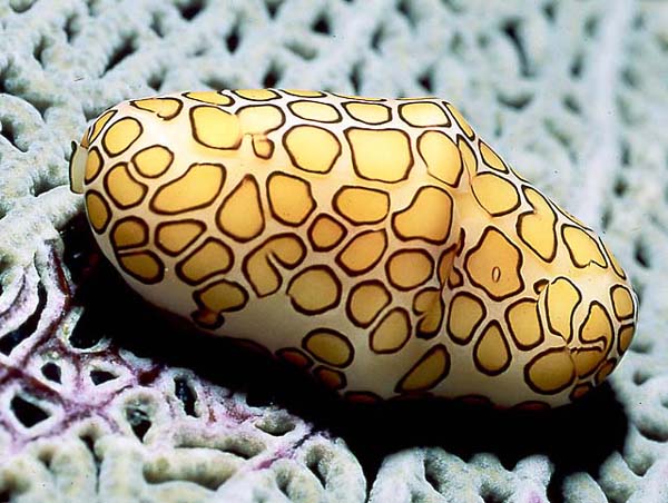
If you examine a sea fan closely you will often find flamingo tongue cowries on them. Cowries are a type of gastropod (like a snail), but are one of the few who extend their fleshy mantle over their shell, so when you look at a live one you are actually looking at its flesh, which is spectacular. Check out this lovely photo my camera never could have taken.

I managed to stay in the water about a half an hour, then returned the the beach to warm up a bit before clouds covered the sky and it became chilly out. I returned to my tent and ate a granola bar, carrots and chips for supper (not exactly gourmet, but it was a 45-minute walk to the nearest restaurant) and I was exhausted. I was falling asleep. I had only been awake for 12 hours.

At this time I was just beginning to appreciate the practical difficulties of my condition. I had somehow acquired a type of arthritis about a month previous, was still awaiting a diagnosis, and found my condition worsening while I waited. I could not keep my eyes open. It's true that I'd gotten quite a bit of exercise this day, but I felt like I'd been awake for 48 hours in some kind of Caribbean decathlon. I was asleep shortly after 8 PM.

Wednesday, May 06, 2009

Update!

Sorry about the lack of entries... I am just about to finish up my exams here and so will have more time to continue the Culebra story in the next couple weeks. (After that, it's off to Wyoming!)


I finally got my underwater pictures back from Wal-Mart. This is good, because the next part of the story involves snorkeling. I got the pictures for free because they were late, which is good, because the care taken in developing them seems to be a little lacking. Some of the prints I was given (which I did not want) didn't make it onto the photo cd (which I did want), and they're all pretty crappy, though this is as much the fault of the cheap camera I used as anything else. Anyway, they will be forthcoming.