Painted Desert

Painted Desert

Monday, October 25, 2010

Splendor


I am writing from the Geological Society of America conference at the Colorado Convention Center in Denver, where I’m currently taking a break from watching presentations on geocognition, or how people think about the geosciences. Time for an update on our latest adventures.

When I last left off, we were driving north through Utah after having visited the five national parks in the southern part of the state. We camped the next couple nights at Antelope Island State Park, in the Great Salt Lake. This place is beautiful, an unspoiled island with a lot of wildlife and great views of the salt lake and the mountains beyond.


The next day, we went to Salt Lake City, to see what there was to do. The answer is: not much. The downtown was almost empty, and (perhaps most tellingly) the city was full of free parking, with even the most centrally located lots costing only $3 a day. We went to a small art museum and to the Mormon temple, which was a very interesting experience in which we spoke to many missionaries without particularly wanting to.


Above, the temple; below, the tabernacle, where the famous choir sings. I had a chance to flip through a free independent newspaper and saw that the Red Iguana had won Best Mexican for the nth year in a row, so we went there for lunch.


Somehow we spent over $60 on lunch there, though I don’t remember exactly why, because I collapsed in a kind of nap-coma later and slept for a while in my tent. But that evening and the next morning we had a good time exploring the island.


Shorebirds on the lake, which is quite shallow.


Antelope. There are antelope on antelope island, but mostly we saw buffalo. I thought I was done with buffalo! These were introduced to the island and are the most famous residents.


We also saw this guy. Katie was extremely disappointed because the driver of this vehicle was not, in fact, wearing a vest.

Eventually, we got ready to go for a dip. We couldn’t pass up the opportunity; neither of us had been in the salt lake before. The air was about 70 degrees with a light breeze, which was just enough to stand around in our bathing suits (and goosebumps), though the water temperature was in the 60s. It took quite a while to walk across the beach to the water. It felt like about 10 minutes. The lake basin is extremely shallow. Even once we got to the water, we had to keep walking for a while to get to a place that was deep enough to float. I stopped to take a look at the sand, which is very interesting:


It is made of ooids, or spheres composed of layers of carbonate that have precipitated around a central nucleus (such as a shrimp poop). The only other place I’m familiar with that also has oolitic sand is the Bahamas (though I’m sure there are others).

Katie actually got into the water first… well, I was taken off guard by her courage, I’ve never been able to drag her swimming with me anywhere if it was less than about 95 degrees.


Then I got in. It was quite cold, of course, but we floated around for a few minutes. It is actually a very fun sensation and quite noticeably different from being in regular salt water (the actual ocean averages 3.5%… this section of the salt lake averaged maybe 14%. (Some sections of the lake, cut off by causeways, are up to 25% salt). Despite the cold we had tremendous fun.

On the long walk back to the parking lot I dried off and the salt made my skin sparkly. I looked like a donut dusted with sugar.


Before we left, we went on a drive around the island. Though we had just come from what was obviously a very geologically interesting area (that being southern Utah), the Salt Lake area is also fascinating. In this less-than-fascinating picture, you might be able to see horizontal lines on the hillside:


These lines are terraces that mark the former levels of the lake. During what is colloquially known as the Ice Age, the continent was much wetter, and a huge lake—called Lake Bonneville—occupied this and surrounding basins, with some of the local mountain peaks just small islands in its expanse. Click here (http://www.greaterthings.com/News/daily/2005/09/06/6600916_Bush_behind_Katrina/Lake-Bonneville-and-Utah.jpg) to see a graphic. At its deepest, the lake would have covered all of Salt Lake City, lapping against the mountains above it.

About 14,500 years ago, the lake breached through a pass in Idaho and its level fell 350 feet in a year, releasing perhaps 1,000 cubic miles of water in the first few weeks. The water rushed through the Hells Canyon of the Snake, leaving gravel bars that can still be seen there now—100 feet above the present river level.


Buffalo butts.


We came upon a couple coyotes that were hunting along the road… I guess they were pretty used to cars. Below, an extraordinary video I was lucky enough to capture of a coyote crossing the road in front of our car and pouncing on prey in the scrub:


Not only is the area interesting for its Lake Bonneville history, but Antelope Island also has some of the oldest and some of the youngest rocks on earth. Above is a very old rock: 1.7 billion years old. The youngest rocks, deposited as Lake Bonneville retreated, are less than 15,000 years old.


When we got to Twin Falls, ID, to visit one of Katie’s aunts, we found she had put us up in a hotel. Mostly we were interested in the showers as we were still very salty. We visited Craters of the Moon National Monument while we were there. Here is some pahoehoe (ropy) lava frozen in the form of basalt:


And here is a kind of volcanic bomb that cooled in such a way to give it a “bread crust” appearance:


And one of the craters out of which cinders erupted:


And a less-than-illuminating shot from inside one of the (empty!) lava tubes:


All this was a big departure for us, as nearly all of our previous explorations had been made in sedimentary rock. Large sections of Idaho, however, are covered in basalt, some of which has come from the same hot spot that has been migrating east over time to where it now sits beneath Yellowstone. (By the way, one of the displays at Craters of the Moon informed us that the area is due for another eruption sometime in the next 1,000 years, so “now is a particularly pertinent time to visit the park.” I suppose so, if by “now” you mean “sometime in the next 1,000 years.” We should be able to manage that.)

Some of the other basalt in Idaho is part of the Columbia River Basalt Group, which formed in a serious of lava floods that eventually covered 63,000 square miles of the northwest and is, in places, more than a mile thick. This is one of the largest flood basalt events on the planet.

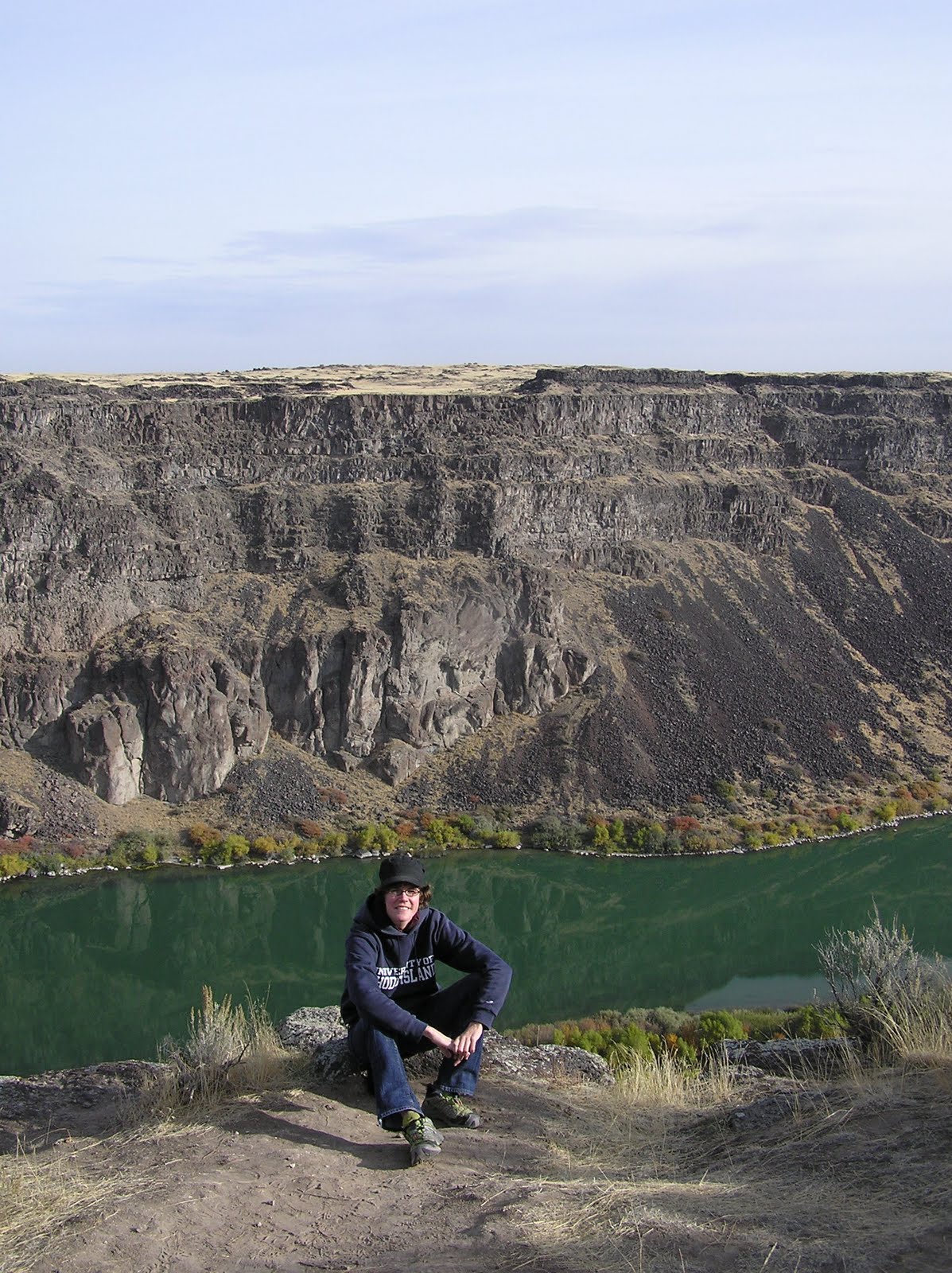
Twin Falls is in an odd setting. Driving around most of it, all you can see are flattish yellow fields stretching to the horizon. It seems like a very flat place. And then you come upon this:


There are giant, gaping canyons here. People use them for recreation, as we saw.


Above, the “terraces” visible on the canyon wall may be from separate basalt flows.

Next we drove into the Sawtooth mountains, which have been said to rival the Tetons in beauty. We didn’t see very much of them, unfortunately, because we didn’t know what we were doing, but we did go on a short hike that took us up to a couple of mountain lakes. It smelled like winter in the forest, which was completely silent and had patches of snow and ice already. The sky was a heavy grey. When we came upon Washington Lake it was so silent and still I thought the scene only required snow to perfect it. But it wasn’t going to snow because the temperature still felt like it was in the 50s. Then it started to snow.


You may be able to see the snow in these pictures if you click for detail.


We camped that night a bit lower in elevation, though it was still quite cold. One of Katie’s cousins had given her a device called Mr. Heater. Mr. Heater ran on propane and got extremely hot, and we never did find a way to use it in such a way that it actually kept us warm at night without melting the tent or suffocating us from carbon monoxide.

Next we went to visit another aunt who lives in Clarkston, WA, on the ID border. She took us to see some petroglyphs. I think this one is evidence that indigenous peoples developed weightlifting long ago.


The hills here are all basalt too. While here we went to visit the U of Idaho at Moscow, where my brother went to school. The most important thing we saw, though, was her aunt’s kitten, Kato, who was excruciatingly cute and with whom we played quite a bit.


Next we camped outside Riggins, ID. Here, we have made the tent with two backs, in an attempt to use Mr. Heater without melting any nylon, but unfortunately the heat wanted to escape out the sides and not go into either tent.


We were here because we wanted to see the Hells Canyon of the Snake, the deepest canyon in North America, with a drop of over 8,000 feet from the highest point on the rim. Despite these distinctions, neither Oregon nor Idaho has made much of an effort to turn the canyon into any kind of tourist attraction. The quickest way to get to the canyon involved a winding dirt road that was going to take us, by various accounts, either an hour or half a day to ascend to the canyon overlook. The scenery was beautiful on the way up…


Unfortunately, as we climbed in elevation the snow became too deep to proceed through. We were just a couple days too late to see the canyon. We had to turn back. So much for that particular geological wonder.

Next we visited a third aunt in Boise. Boise seems to be a very nice town. It has many beautiful, old houses, and the trees were turning orange… I could have believed I was in New London or Westerly again. It is surrounded by mountains that were just getting their first snow.


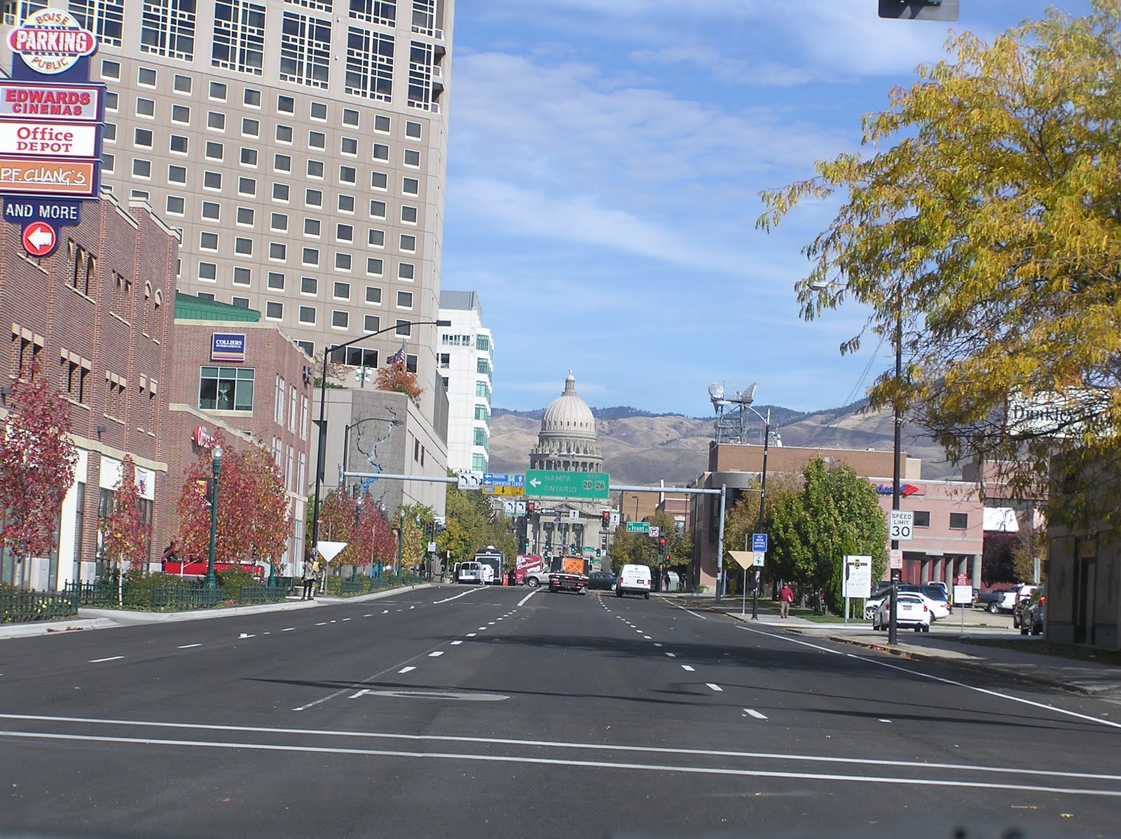
A shot of downtown Boise. (Note: the real Boise is not slanted like that.)

When we camped that night on the ID-UT border, I had what was to me one of the funnier moments of the trip.


It’s not immediately evident what has happened in these pictures, but in fact Katie zipped up her jacket without looking and didn’t realize until a bit later that she’d made a mistake. I suspect this is how trends get started. Unfortunately, no one else was around to see it, because it was in the 20s that night and nobody in their right mind was going camping.

Our final bit of the drive back to Denver saw plenty of snow on the Front Range…


But once we got into Denver it was quite temperate. It scarcely matters, though, because we’re spending all our time inside. Here, a shot of the convention’s exhibit hall on opening night:


We were enjoying all the free things that the various companies and organizations were giving away (and the free beer registered conventiongoers got). My favorite were the rainbow glasses. Here, Katie (full name blurred to protect her reputation) and another former URI student show off their frames:


And finally, to revisit that shot through the rainbow glasses, allowing you to enjoy the convention with me in all its splendor:

Wednesday, October 20, 2010

Sponsored by the Southern Utah Travel Bureau

Warning: there is a large spider toward the end of the post. Those of you who are sensitive (and I know there is at least one of you) may want to avert your eyes.

Well. We have had many adventures since my last real post. We never did get the torrential rain, flash flooding, and tornadoes the weather forecasts predicted, and we did get to do lots of hiking in the Moab area.


Here is the car at William’s Bottom campground west of Moab. This $8-a-night campground was ideal in its beauty and central location, and non-ideal in the fact that potash trucks started screaming past on the highway 30 feet from our tent at 7 in the morning, and the fact that campers seemed to want to move in noisily in the middle of the night every night, which left our new friend Tom the campground host in a state of occasional exasperation.


Fog on the morning we drive to the Island in the Sky district of Canyonlands.


Here we are high above the canyon-lands below, indeed above the clouds that are lingering in the late morning. We took a long hike here that went down to the rim of the inner canyon you can see in the distance in this picture.


Our hike was very interesting as it crossed through many geologic formations representing different environments.


Here is a picture of very well-preserved fossil (over 200 million years old) ripples of a kind you sometimes see forming in shallow water.


Here are similar ripples that had been formed the day before as a storm left the wash we were in briefly flowing with water. I found them just downstream of the fossil ones.


Katie brought her Roadside Geology of Utah book on the hike. Here we try to determine the formations that we see in the distance. When it comes to learning about the geology of the places we go to, I am mostly interested in what formations I am seeing; because I may have studied some of them (such as the Chinle Formation) in the past, and am curious to see how they differ in this place. In Canyonlands, for instance, the Chinle had a lot of orange and purple, but it is mostly red where I worked at the Petrified Forest. If the book mentions a formation I am not familiar with, I want to know how old it is and in what environment it was deposited, helping me form a more complete picture of the series of shallow seas, floodplains, deserts and lakebeds that occupied the Four Corners region from the Paleozoic through the Tertiary.


Katie insists she has found fossil bone. It just looks like a little black rock to me, but she is very smug in her certainty.


A sight of the inner canyon. (To get back to our car, we will have to climb back up the Wingate Sandstone, which makes the very steep orange cliffs in the far background. We don’t scale the cliffs, though, the trail makes switchbacks up bouldery debris flows.)

The next day we went to the Needles District of Canyonlands, to the south, where the rocks are older and erode into pinnacles.


Here is where we were going to hike through that slot canyon the day the flash flood warnings were being issued. This canyon is called “the Joint,” and it was in fact formed from a joint, or typical kind of fracture, in the sandstone, rather than being completely eroded by water.


This place was very cool (figuratively and literally), with black walls rising at least twenty feet above a pink sand floor.


Oh, yes. Back at William’s Bottom, a balloon soars overhead.


The next day we went to explore the Fiery Furnace at Arches, which is neither fiery nor a furnace, but an area of sandstone fins, arches and pinnacles that can be explored only by ranger-led tour or special permit. We watched a short video in order to get our permits. The video was all about how we shouldn’t step on the cryptobiotic soil, which is held together by filaments created by cyanobacteria. These filaments prevent the soil from blowing away and doing anything from smothering nearby plants to landing on Colorado snowpack and hastening its melting. Anyway, Arches is very serious about this not stepping on the soil thing; you are only allowed to walk on bare rock or through washes (dry streambeds). When we got to the Fiery Furnace, we had quite a fun game of finding a route through the area by hopping and climbing over rocks, occasionally meeting a dead end at either a sheer cliff or patch of rockless soil.


Katie tries to climb around a rude juniper tree that has blocked our path. It was odd how fun this was. There was a lot of pressure not to fall, but after all, the only thing that was going to happen if we did fall was that a few bacterial threads would be torn. (And a patch of the Colorado snowpack would die a little.)


Above, climbing; below, one of the narrow slots through the Fiery Furnace.


After that, we went backpacking in Arches. We had been going to go in Canyonlands, but didn’t, for a couple of reasons. When we went to get our permit for backpacking at Arches, they told us, “Nobody really goes backpacking at Arches… Canyonlands is much more popular.” I said I knew but that we wanted to go. They told us to walk up a wash toward picturesque Lost Canyon. This sounded fine.

When we got to the wash, it wasn’t a wash. It was still completely filled with water from the recent rains. It was basically a very sluggish river. At this point, it was too late in the day to go back to the visitor center and get a permit to go somewhere else instead, so we hiked up through tributary washes to the bare rock walls of the canyon, and traveled above it. In an hour and a half we’d gotten about a mile. The going was getting increasingly rough and so we stopped for the night.


It was quite beautiful high above the waterlogged wash, but we had nothing to do in the hours before bedtime. I had been expecting to hike all evening up through the wash, stopping only once it got dark, and so hadn’t brought anything to read. Katie hadn’t brought anything to read because she’d only brought what I told her, this being her first backpacking trip (and a pretty sorry one so far). We ended up talking until the stars came out, and after, though both of us were freezing. I guess this is what people did before TV (and books).

Then the night was so cold and humid that we spent it soaked and frozen. And tried to find a way out through the soggy valley without destroying any of their precious cryptobiotic soil. We were cold, dirty, and grouchy, and had seen about enough of Arches. We drove on to Goblin Valley State Park, which has a commodity more precious than cryptobiotic soil: showers. Our first in over a week.


The odd hoodoos, or lumpy pinnacles, in Gobin Valley, and our campsite.

Outside Goblin Valley is a popular slot canyon called Little Wild Horse Canyon, which we hiked up into.


I also have a video of following Katie up through the canyon, but I keep forgetting that I shouldn’t take portrait-type videos with my camera, because there’s no way to rotate them. So it looks like she’s climbing sideways.


After Goblin Valley we went to Capitol Reef National Park, which is the strangest national park ever. The scenery was nice, though not really as stunning as many other national parks. Here are the “capitols” formed by erosion of the Navajo Sandstone.


What made the park so strange was that it was also home to an old Mormon settlement, and driving through the canyons one would come upon neatly ordered orchards and old buildings. Apparently, you can pick the fruit when it’s in season. There was also a farmhouse that sold homemade pies and ice cream all day long. We bought some strawberry rhubarb pie and had it with tea one afternoon.


Above is the Narrows, where the Grand Wash pinches in, creating a shady space with sandstone cliffs towering hundreds of feet overhead. Click for detail and find the small figure in the lower left to get a sense of the scale.


That night, we make pizza at our little camping spot on BLM land near the park. There was ice on the car the next morning:


After that it was on to Bryce canyon, which seems to be a photographer’s park more than anything else…


We had also planned to go backpacking at Bryce because I saw on their website that there are springs in the backcountry, meaning you don’t have to carry gallons of your own water with you (one of the reasons we didn’t go at Canyonlands). What I didn’t know, and what wasn’t explained to me until we were getting our permit, was that the backcountry trails at Bryce wind through the forest far from the pink rock the park is famous for. Well. I like backpacking and I had been looking forward to going, so we signed up for just one night (lest the forest prove too boring). It was nice, of course, with good views in the far distance, but we started to run into troubles around supper time.


Though bears are rare at Bryce, the park gives you a bear canister to put your food in, which we had done, but now that it was time to eat I couldn’t get the canister open. Here, Katie takes over. The sunset was lovely on the pink cliffs far above us…


But then it got quite cold, and we slept fitfully, and then in the morning, neither of us could get the canister open. I reasoned that its lid must have shrunk in the cold, and so we poured most of our water, heated to boiling, over the lid until Katie was able to wrestle it open and we could get at our food. Then I had to eat my oatmeal with my toothbrush, because I’d forgotten my spoon.


The offending bear canister.


On the way out, I saw a mountain lion footprint! I had never seen one before.


Here we pose at an overlook before returning to our car.


Sunset on the hoodoos that night.

After Bryce we headed on to the promised land, which is to say, Zion. I didn’t know the first thing about Zion (that it is a canyon, say) before getting there, but it is a wonderful place. It helps that the weather was much warmer there than anywhere else we’d been on our trip so far. We drove around looking for a campsite, passing through beautiful country of many colors both inside and outside the park.


Eventually we settled by a lovely stream on BLM land near the park (whose campground was full, even if we hadn’t been too cheap to camp there… we had managed to hit both of Utah’s most popular parks, Arches and Zion, on weekends). The next day, we climbed Angel’s Landing, considered one of the best trails in the country.

The Angel’s Landing trail climbs nearly 1500 feet through a series of switchbacks, including 12 or so closely spaced ones called Walter’s Wiggles, in a wonderful piece of construction I expect was built by the CCC, like many of the more ambitious trails in our National Parks. It then ascends a sandstone fin that has been left standing alone at a bend in the Virgin River.


Above, see if you can find the people climbing the fin, with a 1,200-foot drop on one side and a 900-foot drop on the other.


Me at the top.


A view looking down on the fin. There are chains suspended at some points on the trail to help you not fall to your death.


One of the many views to be had from the top. Zion’s cliffs may be the highest sandstone cliffs in the world; I say “may be” because the park staff themselves didn’t seem sure.


Katie illustrating for me how the chain is keeping her from falling to her death 1,200 feet below. Hilariously, the park newspaper advertises that the Angel’s Landing Trail is “not for anyone fearful of heights or young children.” I am fearful of young children, yet I managed to hike it. Probably because there were no young children up there.


Here are folks descending Walter’s Wiggles.


Also, we saw a condor. This was pretty amazing. We were up near the top of Angel’s Landing and saw a vulture-looking bird soar below us. It had white patches on its wings and a big pink head. We didn’t quite believe it was a condor, though, until we heard other people talking about it, and noted that the park newspaper did mention there were condors in the park. Here is a picture of the condor soaring in the distance… when it was not far below us it looked much cooler, but it was out of sight too quickly for a photo.

Zion’s landscape is like something out of a fantasy novel, or illustrations of deepest Africa you might have found in a turn-of-the-century children’s novel. Steep, orange-stained cliffs rise above the trees around every corner.


We climbed another trailed called Hidden Canyon, which turned out to not so much be in a canyon as have a canyon at the end of it that you could hike into, trail-less, finding your own way over the trees and boulders that had choked it in previous flash floods. We spent a couple hours in there, gazing up at the sheer storybook cliffs visible high above us, then returned to the trail, which also gave the impression of being somewhat death-defying.


And there was a tarantula. I am not reaching for it! Just have my hand in the picture to give you a sense of how big it was. Without the hand:


This tarantula was very cute and was walking very delicately down the trail, lifting and setting down its little feet with great care, like some kind of hairy ballerina. I took a movie of it walking, for people who like that sort of thing:


Here is a photo of the spider with people, for a sense of scale. I wanted Katie to stand with it to have her picture taken but she refused. It was the most she would manage to step over it. And it had to be stepped over because the trail was so narrow. Apparently the males come out in the daytime in the fall to look for mates, and that is the only time they will be seen during the day. We saw another one the next day.


Tea and cookies in the evening on rocks in the stream by our campsite. We are on rocks in the stream because the place was crawling with ants.


Next day, looking up at the skyline in Zion. The place has great names. The red-stained cliff to the right of center is the Altar of Sacrifice.


The Three Patriarchs, Abraham, Isaac and Jacob.

You are not allowed to drive up into the canyon during the busy season and must use the park shuttles, which come by every few minutes and then coast away on trafficless roads. We took the shuttle to the top of the canyon, and then hiked to the Narrows (yes, Capitol Reef had a Narrows too) where the canyon becomes very tight, and it is very popular to hike up into its slotlike bends wearing river shoes and carrying hiking poles to prevent you slipping in the 50-degree water. Supposedly it is very beautiful in there, but Katie and I did not have the proper equipment.


The canyon narrows here due to a quirk of geology; canyons in general widen not so much through direct erosion by the river as through undercutting. Weak layers of shale are easily eroded and taken away, and sandstone or limestone walls above them are left with no support, and eventually collapse. South of the Narrows in Zion, the Kayenta Formation is being eroded by the river, undermining the tall cliffs of Navajo Sandstone above it. North of the Narrows, the Kayenta has not been eroded down to and still lies below the earth. The water can only cut through the strong Navajo and so it forms a narrow slot.

As I write this, Katie is driving us up I-15 in Utah toward Salt Lake City, past mountains, deserts, and cinder cones from old volcanic activity. We will spend a day exploring the city and then go on to see her relatives in Idaho, where no doubt it will be cold. Farewell to the promised land!