I have been back from my river trip for some time, but only now do I have a moment to write about it. On the last entry, I spoke of the desirability of the Yampa trip, the wild untamed river that few get to see, and how it was at a much higher flow than usual due to the heavy snowpack and unusually enthusiastic spring rains.
When we put in at the east end of the park, the Yampa was flowing at 16,000 cubic feet of water per second; its usual flow this time of year is 4,000 cubic feet per second. The river was yellow-brown with all the silt in it and it was impossible to see your hand in it past a depth of a few inches. All of the sand bars usually present in the river were submerged, along with most of the plants on the sandbars, including the ones we were there to look at.
The purpose of the trip was to record the numbers of tamarisk beetles present on the tamarisk in the river corridor. My eastern readers probably won't recognize the name tamarisk, but it's a major invasive species that costs the US massive amounts of money each year. When cattle grazing was introduced to the west, the cattle trampled and destabilized riverbanks, and tamarisk were imported from Eurasia to stabilize the banks. You could say the invasion is a case of the plant doing its job too well; it now forms impenetrable thickets along riverbanks all around the west, replacing the native foliage that animals like to eat or nest in, and preventing anyone recreating in a boat from being able to get to shore (or anyone recreating on land from being able to get to the water). Tamarisk also has very deep roots, and draws up far more water from the ground than it needs for survival. This lowers the water table, causing some streams to disappear completely.
Every time I tell people that the US released beetles from Eurasia to combat the tamarisk, their natural food, someone says, "Oh, I hate when they do that." Because most people have heard of stories in which a species deliberately introduced for some (seemingly) good reason finding new prey, interbreeding with native populations, et cetera, and in general causing some kind of ecological havoc. But the truth is that of all foreign species introduced, the majority don't survive or flourish, and of those that do, only a handful will go on to become problem species. Perhaps one out of ten "exotics" brought to the US will ever spread outside of where they are originally planted, and only one in ten of those will ever become a problem. Considering these odds, and the fact that we lose so much money on tamarisk issues each year, introducing the beetles was simply a better solution than not introducing them. Of course, many studies were performed to determine whether the beetles would like to eat other, native US plants (they would not) before they were released. And now here we are to monitor how they and the tamarisk are doing, several years after being released in the park.

I took this picture while drifting past some teammates who had found tamarisk to sample. The insect net was swept agains the plant and the number of beetles and larvae in it recorded. We tried to do this at least once per mile of river. More on how the beetles are doing later!

Here are our two boats, tied up at a campsite. If you have done whitewater rafting before, you may have ridden in a paddleboat, propelled by six or so paddlers; these are oarboats, propelled by a single oarman, and they are much heavier than paddleboats, housing an internal frame and some metal dryboxes and coolers. Also, during the day, they carry all of our drybags with our gear, and 2-3 people each.
The river goes through canyons. Some pictures:


Camp:

On our second day we went through my first set of rapids, the Tepee rapids, which were lovely. Several things cause rapids; one is a change in gradient, or how steep the river is. The most exhilarating moment on the rapids was when I could see that the boat in front of us was also far below us, as down a hill. (I'm used to water being, well, horizontal.)
We got to do many things besides sampling beetles on the trip, including looking at pictographs. What is the difference between a petroglyph and a pictograph? Petroglyphs are pecked or scrached into the rock, but pictographs are painted. Here, a strange figure and some writing. I assume both of these are modern; the human figure looks nothing like any of the other art of ancient peoples around the area.

Our third morning on the river, it stormed and many waterfalls began spouting off the cliffs far above us. It was fascinating to watch; there would be nothing for a long time, as it rained and rained, and then all of a sudden water would begin pouring off somewhere. The land above the canyon walls, so much bare rock with nowhere for the water to seep in, had gathered the rain up and channeled it into a stream that finally made it to the canyon edge.


Another group's campsite, showing the magnificent canyon wall behind.

More canyon photos.


In the second is the Grand Overhang, beneath which we were subjected to a ritual in which we lay down on the boat and were spun about:
It became stormy again later that day. As the clouds came in I took a picture of our other boat's occupants trying to kiss the Tiger Wall. Kissing the tiger wall was supposed to bring you good luck at Warm Springs, the most dangerous rapid on the river, which we would face later that day.

Shortly after the attempted kiss, it began to look quite stormy, and we pulled the boats together and discussed whether to take lunch on land, sheltered under an overhanging ledge, or on the river. Due to the frightening number of mosquitoes we'd been experiencing on land, we decided to stay on the river, exposed as we were. We tried to eat very quickly but all the same we weren't quite finished when a wind whipped up, upstream of us. We could see it beating the water to a froth. I was confused why it wasn't windy where we were, but then it was, and rain was pelting us. Then hail was pelting us. The hail was the size of peas; then it was the size of macadamia nuts. The water was frothing all around us with the hail falling into it and then the wind got faster, and then faster, until gusts of 50 or 60 miles per hour made the hail feel like rocks on our body, anywhere that wasn't protected by the life jacket.
I had gloves on and I put my hands over my head to stop the feeling of rocks hitting it, but the gloves were no help protecting my tender finger bones and I decided it was better for my skull to bear the impact. It went on for some minutes and I looked back to see our oarman, one of the park botanists, still pulling on the oars, although we weren't moving at all. We could see no more than 20 feet in any direction; the banks were lost in the rain of hail, and all he could do was keep our backs turned to the wind.
After seven, or ten, or fifteen minutes I noticed we were right next to the bank. The hail and the wind were already lessening but we pulled under an overhang and waited until it stopped. Everyone was very cold and bruised. As we waited more streams and waterfalls formed around us, as the waters from above came together and reached the canyon's edge, which was fascinating to watch.
I spent most of the rest of the day very cold. I had full rain gear on and wasn't wet, but still, I had been covered in ice and water and the sun didn't come out for a long time. We reached Warm Springs, the mighty rapid. When we got out to hike down the shore and scout the rapid, I ran in place for 15 minutes to try to bring feeling back into my hands and feet.
The rapid here was created when the canyon wall collapsed in a massive landslide in the 60s (on a day just like this, no doubt, when mighty storms saturated the ground with water). Our guides had been thinking about the rapid all day and our trip was planned so that we would go through it with plenty of time remaining until nightfall, in case anything went wrong.
Warm Springs rapid is dangerous because it has several "holes" that will flip a boat quickly. A hole is formed where water pours over the top of a submerged object and, below it, swirls to flow back upstream toward the object. Sometimes they quite literally look like holes also; the water at the bottom may be five feet or more below the water surging before and after it. The steep slide into a hole may capsize a boat, or the confused currents may do so; in some holes a person, overboard, may become trapped under the water and drown.
It took only a few moments to get through Warm Springs and we were wet but umharmed. It was almost nothing. But the only reason it had seemed almost nothing was that our oarmen had been both skilled and lucky at steering the boat through the rapids without getting pulled into any of the holes.
We pulled into camp about 3 PM and almost immediately afterward, the sun "set" behind the high canyon wall. Not much chance to warm up!
I wandered over to the camp next to ours that night and spent some time talking with the private rafting party there. Many of them had been rafting for 30 years and said they had never seen a storm as bad as the one we'd just been through. They also sang me happy birthday (my birthday was the next day); it is an oddly touching thing to be sung to by 15 strangers.
The next day we had some real sun. Here is Mitten Park Fault (as seen in a previous blog entry), this time from the water.


Me in my odd outfit of swim shirt, gloves to prevent sunburt hands, and rain pantaloons. After sitting all the first day in water I decided I didn't want to endure any more wet butt. It was odd being on the river... I am so used to the ocean. Every time I got splashed I was dismayed, thinking I would be wet forever. But no, of course the sun would dry me... I wasn't going to be covered with salt for the rest of the day, which attracts moisture right out of the air and keeps you continually damp and sticky.
There are many interesting things to see on the river. An inscription of a fur trader from the 1830s!

Here is the contact between two formations. The darker, blockier one, on the bottom, was on the edge of the sea and was eroded into sea stacks, or pinnacles at the shoreline. Then sea level dropped and sand blew in and surrounded the sea stack here, and became the lighter formation above it.

Another sea stack inundated by sand.

On our last evening in the canyon we hiked to a funny waterfall that one of our guides called "butt dam falls." See the video:
Me:

And some nearby pictographs:

Finally, a view back down toward the river:

All of my wilderness trips have previously been varieties of backpacking, and I am used to being able to carry and use only certain things. But on a river trip, with those big oarboats, we carried quite a lot of gear. Here is our kitchen, with table, stove, compost bucket, handwashing station, and more:

We washed our hands and dishes in river water with bleach added, but brought many gallons of potable water for drinking and cooking with. The coolers allowed us to bring meat to cook. We even had a toilet that we had to use for solid waste, because with thousands of people enjoying the river corridor every year, people would soon run out of places to dig latrines.


That afternoon as I stood on the riverbank, the party I had met on the previous night drifted by on their own boats, in ones and twos, each of them yelling out happy birthday when they saw me. And that night I went to visit another group, a commercial trip, who also sang to me. This was very nice.
On our last day we sampled yet more tamarisk... the beetles are fine. They have plenty of tamarisk to eat. They will never rid the land of tamarisk, only weaken it (although we did see at least one tree that seemed to have been killed by the beetles). Many populations had moved on from where they were first released. The high water of this year had also killed many tamarisk, with drowning or battering with driftwood and such.
As we neared the canyon exit (and the boat ramp) I was allowed to "ride the bull," or sit on the front of the raft gripping where the ropes attached. I went over several sections of whitewater this way. Here is a picture of my teammate doing the same, on flat water:

I also got to practice rowing. The oars are ridiculously heavy and I don't know how our guides managed to row all that way. (Thankfully, the river was flowing so fast they didn't really have to row the whole way, just steer us.)
I enjoyed the trip very much but was happy to be back on land at the end. I did not really like being wet so much. However, I would recommend a river trip to anyone.


 A trackway showing several three-toed prints.


 Unlike body fossils, which are best preserved by being buried quickly, tracks seem best preserved if buried slowly. A dinosaur may walk across a damp sandbar in a river; if the sand is fine-grained, or has some mud in it, the tracks may show up nicely. They may dry out a little and start to harden, before the rains come, the river rises and slowly more sand or mud is deposited on top of the tracks. (To learn more about dinosaur tracks, check out this very interesting site.)
 These are Brasilichnium ("trace from Brasil") tracks, made by a mammal-like reptile walking up a dune face. We know they are tracks because of the "push-up," or crescent of sand behind them that modern trackmakers also leave. (Click here to see some better Brasilichnium tracks.)

 The first two were, perhaps, made by beetle or fly larvae feeding in the sands. The third may have been a spider or scorpion burrow.
 And some burrows may be seen in relief as the sand weathers:
 But so far, the only tracks I and my partner have found have been the tracks of arthropods (perhaps spiders)--no dinosaurs, no early mammals. They are shown here:


 Here, we help a team from the university carry out a slab with traces on it made by a swimming reptile.
 Very small tracks, presumably from an arthropod! That is my compass in the corner.
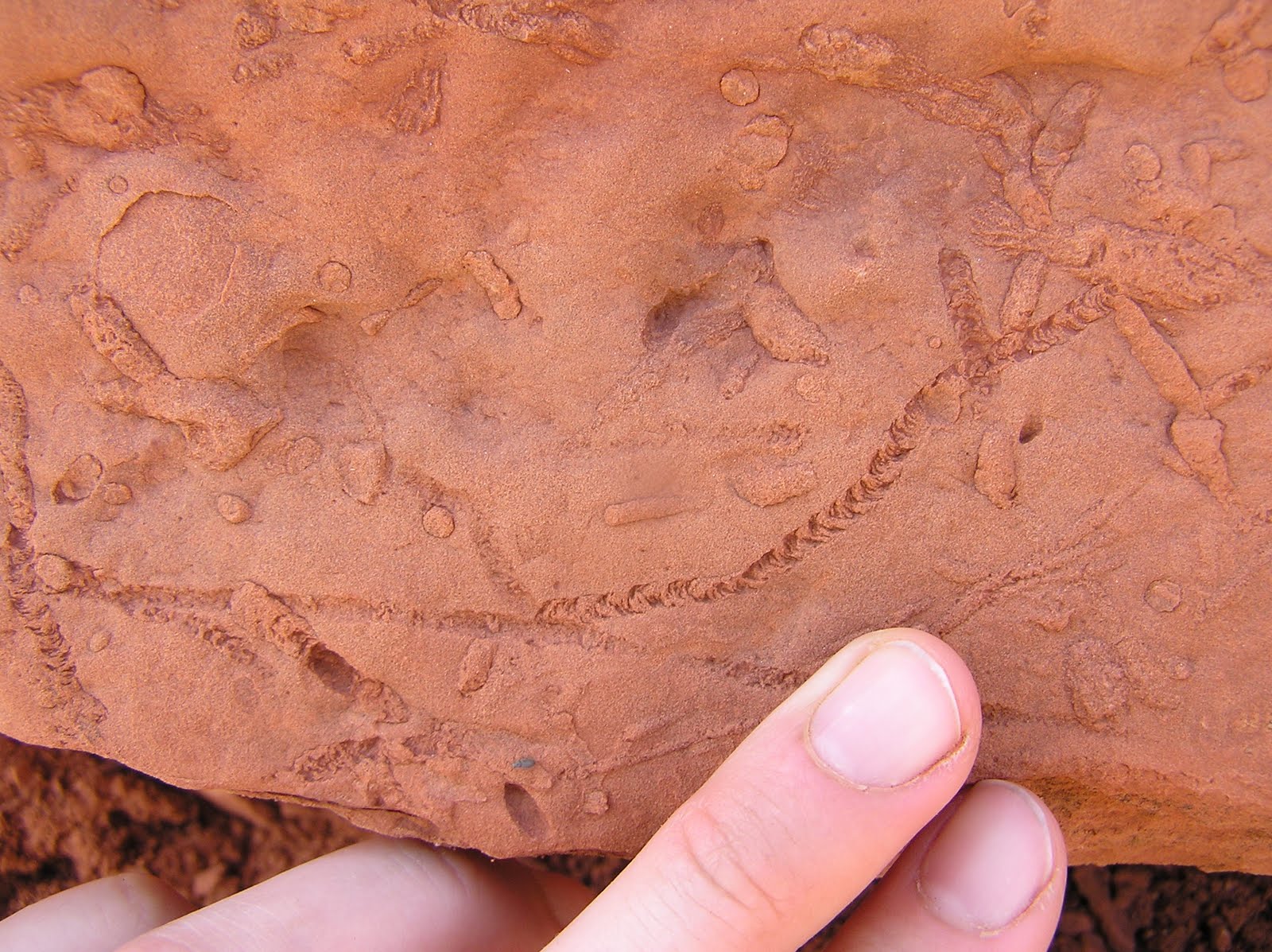 Very nicely preserved burrows.
 Lizard footprints. There are three of them in the picture, though they are a bit difficult to see.


