Our latest adventure was in the Snowy Range of Wyoming, famous for the 12,000' Medicine Bow Peak and its giant grey-white cliffs that face out toward Laramie on the plains. We had planned to do a 15-mile loop to circle nearby Browns Peak with a spur to climb Medicine Bow, but just before starting had decided we could probably do the larger, 20-mile-ish loop around Browns and up over Medicine Bow.

We'd chosen WY because the forecast for Colorado looked poor, with rain all weekend. Wyoming only had rain forecast for Friday. We took our time packing Friday morning, made the ~3h drive and were hitting the trail from the Brooklyn Lake trailhead about 3pm, going counter-clockwise.
Despite taking our time packing, we'd forgotten a couple of important items; my new prescription insoles for my bad foot were one. Since I had just the one pair (they were $400!) I was having to swap them in and out of my various shoes, and I'd neglected to make sure they were in my hiking boots. Neither were the stock insoles that came with the boots. My poor foot wasn't going to get any cushioning.
The other important forgotten item was A.'s inhaler. She has asthma and has had midnight attacks on past trips, wheezing in the tent in the dark, which is a little scary. But, there we were. We weren't going to turn back and so we headed out.

It was immediately beautiful. A few hundred feet in we already felt we were somewhere very remote and wild, with small ponds surrounded by flowers appearing through the ragged pines. Large snowbanks lingered. It had started to rain just before we exited the car, and now we could hear thunder in the distance.

Stream-tunnel through a snowbank
We were concerned about the thunder. The map showed us climbing above treeline, although as we progressed we saw that there were always trees around, even if they were becoming stands of trees rather than a contiguous forest.


Neither of us particularly wanted to make camp for the night only half an hour from the car, so we reasoned that as long as there were trees around, we could duck into a patch of forest if the storm came closer. In fact this is not the safest thing we could have done, and I knew it at the time, but I also knew that our chances of being struck were still extremely small. But, probably don't do this.

Eventually we saw lightning in the distance to the north. And the trail in front of us crossed a large open meadow with no trees. But the wind was blowing from the south, so we made a run for it, jogging across the open area.

(Of course, I still stopped to take a picture.)
It was scary, but we made it to better tree cover and started to head downhill. Then, suddenly, the wind changed and the storm to the north started blowing toward us. It was on top of us very quickly, the sprinkling rain turning into a cold downpour as we struggled to get extra layers on underneath our rain jackets. Lightning struck just to the north -- it seemed to flash pink and green -- and A. counted one, two, three until the loud thunder boom. This happened a few times. Then the next flash was to the south... one, two, three, boom... then the thundery part of the storm seemed to pass on south, leaving us with just the rain. We waited to see if it would let up before we set up the tent.

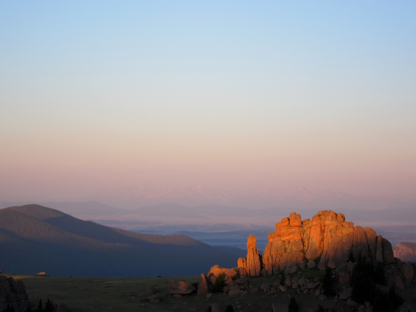
Browns Peak in the distance
We were very cold. I suggested exercise to keep warm, which turned spontaneously into chasing each other in a tight circle around a 2' tall pine sapling, laughing. It wasn't enough to warm us up but since we were just standing around we decided to cook dinner: mashed potato flakes with peas and bacon.


Scooping water from the lake
Finally, the rain tailed off. There were still a couple hours till dark so we decided to keep hiking. We came to a trail junction and I, remembering we wanted to stay on the Sheep Lake trail, led us to the right. Eventually we camped by a large lake we thought was Reservoir Lake, despite the trail not running quite as close to it as the map said. We had a lovely view of the hump on the north end of Medicine Bow's long ridge that the map referred to as "Wrong Peak." (The real peak was out of view to the south.)

And then the sun came out, just as it was setting, making all the rain and cold and frightening lightning worth it with one of the greatest sunsets I've ever seen in my life.

Posing in a field of bistort, the white pom-pom flowers that look like giant falling snowflakes

A. points out a deer to the left of the lake
I ran down through fields of wildflowers to the lake for photos, my legs full of energy again, the air fresh and everything golden. There was something Edenic about the moment.


That night, A. did start to have an asthma attack. As we lay awake tossing and coughing in the pitch-black at 1am, we heard another thundering noise. It was hooves. A herd of deer or elk was running. We heard them thundering toward us and then splashing as they ran into the marshy ground near the tent. It was impossible to tell how close they were, and I was about to clap my hands or yell so that hopefully they wouldn't run into the tent (they didn't). Perhaps we had scared them with our noise.
Both of us missed out on a lot of sleep that night, and we didn't wake in the morning until the sun had been up for a while. I love how easily we can look out in the morning just by unzipping the nylon part of the door.

View from the Lightning 2FL
After breakfast we did some stretches while waiting for water to filter. The mosquitoes were just terrible.

And then we found the trail again and hiked off, watching the peaks disappear into the distance to the south. We would eventually circle around to the west to climb the one on the right.

The flowers here in this high-altitude meadow and lake environment were just amazing. It was the highest density of wildflowers I've ever seen, although without a ton of variety, perhaps because it was all around the same altitude. Some massive patches of elephant heads turned whole fields purple.


After a couple hours of walking, I noticed the sun was on our right. That was odd. We should be walking west, and we should be almost at the ATV road that would take us to another trailhead to do the second half of our loop.
We scouted a ways further down the trail, which continued to head north. The trail we were on now had no long north-south sections. We must have gotten off-track somewhere. A. was afraid that when we picked up the trail after breaking camp, we'd actually picked up a different trail; we had exited our campsite toward where we thought the trail was going, not toward where we'd stepped off the night before. Yet, there was no other trail on the map in the area of Reservoir Lake.
I was afraid that we were on some new trail. The map I was using was something I got off the internet... it was made from a USGS quadrangle map from the 80s or 90s. A new trail might very well have been put in since then and we'd never know.
We decided we would just have to backtrack until we knew where we were. Hopefully it wouldn't be as far as our campsite. But as we walked I suddenly knew what had happened, and it was worse than that: at the junction the previous night I'd relied on my memory of which way to go -- after all, I'd only looked at the map about a billion times while I was planning the trip -- but I should have looked again. Now I knew in my gut we had taken the wrong trail and had been off-course since 6pm the night before.
A. was a very good sport about it. It was easier to be a good sport because the country we were traveling through was just so gorgeous, and because it was mostly flat (there's nothing like going 3 hours out of your way down a steep hill, and then having to climb back). We walked quickly and made it back to the junction in just a couple hours.

We had done an extra 6-8 miles and it was just about lunchtime. We found we'd actually camped next to Mutt Lake, not Reservoir Lake. (Though, it was difficult to read on my printout so we called it "Meat Lake," while knowing that couldn't possibly be the actual name.) It was a relief to be back on the right trail and be seeing new country again, including this big (presumably mountain lion) footprint:

I had my low point of the trip as we approached the junction where, if we'd been doing or originally-planned 15-mile trip, we would have turned south onto the Gap Lakes Trail and hiked between the two peaks. My foot was starting to kill me. It was the most mileage I'd done in an 18-hour period since injuring it, and I had no insoles, and now it was the most painful it'd been since the original injury almost a year ago. I was limping and didn't know how much worse it would get. I worried over whether to tell A. we should turn up ahead and skip the larger loop. In the end I decided to just keep limping along behind her; if it was still bad in a couple miles we could turn around then.

Eventually we came to the real Reservoir Lake, which was lovely. I soaked my foot while A. played on a log (and cleaned up my calf where I managed to gash it on a razor-sharp rock). When we got moving again my foot felt better.

The scenery continued to be beautiful, although there wasn't tremendous variety. How many meadows filled with wildflowers and lakes can a person take? We started naming the lakes that didn't have names on the map. Dragon Lake, Cerulean Lake, Forgotten Insole Lake. As we made our most difficult rock-hop across a stream and got to Quealy Lake (we didn't name that one!) the flowers were at their densest yet, and quite a bit of hunting was required to find where the trail actually went. We'd seen almost no one so far, but here where the Quealy Lake Trail joined the ATV road by two falling-down cabins there was a family playing.

We were very tired by then, but A. was unimpressed by the scenery around the ATV road and wanted to keep going, to camp somewhere beautiful once more. We walked and walked and walked uphill on the dirt road, playing games to keep our mind off the slog (How many things can you think of in a kitchen that start with S?). We came to the Dipper Lake Trail and continued on it. Still in search of views, we turned off onto the Heart Lake Trail but stopped by the first little pond, exhausted, and decided to just make camp. I called it Lowered Standards Pond.

Taken from the edge of the pond
The mosquitoes were even worse than at the previous campsite, and after trying to eat dinner with our head nets on, we escaped into the tent. It was the most incredible relief to be away from them and also to not be freezing cold and soaking wet as we were the last night. Also, I had unknowingly oriented our door to the west, and we had an amazing view of another beautiful sunset.

I mostly slept well, safe from the seventy mosquitoes whining just outside the tent door. The next morning we had this talk:
J: Do you remember the conversation we had during the night?
A: No...?
J: You were making some weird noises. You'd stop breathing and then suddenly go PFFFFFFFFF through your mouth really loud. It woke me up three times and finally I said, "Are you okay"?
A: What did I say?
J: You said, "I think so." I said, "You're not dying?" and you said, "I don't think so."
A: I don't remember!
J: I was afraid you were having another asthma attack. I said, "Are you sure you're not dying?" and you said, "I don't think so..."
A: What was I doing? Was it like this? (blows a little)
J: No, it was like the sound of a whale spouting.
A: I don't remember! I probably was starting to have an asthma attack.
(When we started dating she warned me that she can have whole conversations during the night and not remember them in the morning, but this was the first time...)
We took down the tent from our uninspiring little pond-side site, and it looked even less inspiring. "Wow," she said. "That tent really made the hillside."
We were camped right at the base of Medicine Bow Peak and (after trying to eat breakfast with mosquito head nets on) began climbing immediately, and were soon up in the cool breeze with views all around. The flowers on this side of the mountain were stunted and dry, but there were pikas chirping from the quartzite blocks covering the slope.


It was a really lovely climb, and we were all by ourselves. We were tired but took our time. Once at the top we could look over on the great cliffs and the lakes below.


Many people were coming up the east side, which was much closer to a parking lot. There was a marmot at the top who clearly wanted food. It got within 2' of me, definitely the closest I've been to a marmot.

At the start of our way down there was a snowfield to cross, which was fun.


The flowers were much healthier on the east side. It was a long way down and we were hot and becoming footsore and grouchy by the time we got to the bottom. We still had another 6 miles to get back to the car. The scenery continued to be lovely, but it's tough spending a whole day at 10,500'-12,000' in full sun. We tried to keep covered in sunblock but still both got badly burnt. It was a relief when clouds started to come up in the last couple hours.

In the final stretch we saw some flowers that hadn't been around until then, as well as beautiful green quartzite. There's always something to make you wonder about nature and how things got to be the way they are. But we never saw any more large wildlife than the deer that we saw/heard.


We were still quite satisfied when we made it to the car. It was one of the most beautiful trips either of us had ever been on, as well as an adventure. We probably ended up doing something like 27 miles and survived, even without insoles!
I definitely recommend this trip. There wasn't much elevation gain, so even backpackers in non-optimal shape should be able to enjoy it. I don't know exactly how long the loop is; 20 miles is an estimate based on using finger-measurement as well as some trail signage and listed lengths of different sections on various other sites. A smaller loop on either the east or west half (using the North Gap Lake Trail) would also be lovely and probably about 12 miles in either case. The USGS map below was embellished (with suggested campsites and spur hikes) by another hiking group on the web and I can't personally vouch for the suitability of any of the suggested campsites (especially the ones in lakes), but I don't think you can really go wrong; everything in the area is beautiful.
Water was no problem (obviously), mosquitoes were terrible. The trail was difficult to follow in places, especially in the west, though there were always cairns. I'm not sure I would recommend the west part of the loop to someone who has a poor sense of direction or is bad at recognizing trail, though the section from the Lewis Lake parking to the Medicine Bow summit is fine and highly-trafficked.
We don't have any more adventures planned until late August, when we will actually be trying to do the Four-Pass Loop. This hike definitely helped our conditioning for it!