
We woke early on the morning of our last full day in the park. We wanted to get an early start hiking Angel's Landing, partly because it can be a very hot hike and partly because it is no fun trying to pass crowds of people on a 2-foot-wide ledge overhanging a 1,200' drop. We took the 7:15AM shuttle from the visitor's center to the trailhead, and soon found ourselves pretty much alone. It was very quiet and luminous clouds hung over the canyon. I snapped some shots of Angel's Landing, which is the promontory at right below and to the left in the second picture.


After going up steeply for quite a ways, the trail turned into Refrigerator Canyon, where signs warn hikers to lower their voices in order to preserve the natural sounds. We heard frogs peeping and birds chirping. I took a shot looking outward, back out of the mouth of the canyon:

There is something primeval about Zion -- it reminds you of every old movie or fantasy book cover you've ever seen in which dinosaurs roamed the land.

And yet, Sarah appears to be yawning in this picture. I guess when you've seen one majestic, primeval landscape, you've seen them all.
We ascended the series of 23 switchbacks known as Walter's Wiggles and came up to Scout's Lookout, where I spent about 15 minutes trying to find a place to pee that was out of sight of the handful of people sitting quietly surveying the landscape. I finally had to water the plants in a spot where any of the upward-bound hikers could have seen me if they'd turned around. When I climbed back to the trail, I realized there were vault toilets nestled up behind where we'd first climbed onto the ridge.
But we were ready to cross to Angel's Landing. As you have already read (if you saw my blog post three years ago, written after my first trip to Zion), Angel's Landing is a perch 1,500' above the canyon floor. It's reached by traversing a sandstone fin with sheer drops on either side. Carved steps and chains bolted to the rock help you get across. It is often listed as one of the best hikes in the country and even the world, but it is certainly not for small children or those with a fear of heights.
I actively enjoy heights, but looking straight down to a valley floor some thousand feet below does make my innards quiver. In an enjoyable way. The quiver factor of the climb to the top is mitigated somewhat by the fact that you're looking up most of the way, but if you were to stop and look behind you, you'd get a hint of what it will be like on the way back:

There are very few places where a stumble would lead necessarily to death, but there are a couple. It's an exhilarating hike that requires concentration and sober confidence -- those who get too shaky can become a danger to themselves and others. I'm very grateful that this amazing trail was built and that the park service continues to keep it open despite the deaths that have occurred here, not all of which were due to horseplay. (In fact, it's amazing that only a relative handful of deaths have occurred, especially considering the lack of care we witnessed in a couple of young men racing through the trail after us.)
From the trailhead, it took us an hour and a half to reach the Landing. There were a few other parties up there enjoying the lovely weather, the view and the extremely fat chipmunks crawling all over everyone and chewing open bags of snacks. Well, that wasn't quite as enjoyable. But the views were, of course, spectacular.

And here we are:

My hair looks like it's had a bad fright, itself. The views are literally breathtaking, but it's impossible to adequately capture that sense with a camera. Try holding your breath until your heart is pounding and then looking at the below:


Close-ups of people crossing the fin:


Sarah also had me take this panorama video, for your viewing pleasure:
When we finally descended, we found it useful to turn around and go backwards down some of the slopes, leading to this picture, which makes it look like Sarah is dangling suspended from the chain:

On the way back down we paused in the lovely Refrigerator Canyon. I took some shots of an intricately eroded sandstone wall as a canyon wren's strange song echoed in the cool air. (Click here to listen to the canyon wren's song.)


Afterward, we drove out to the east side of the park, where we encountered some desert bighorn sheep ewes grazing beside the road.


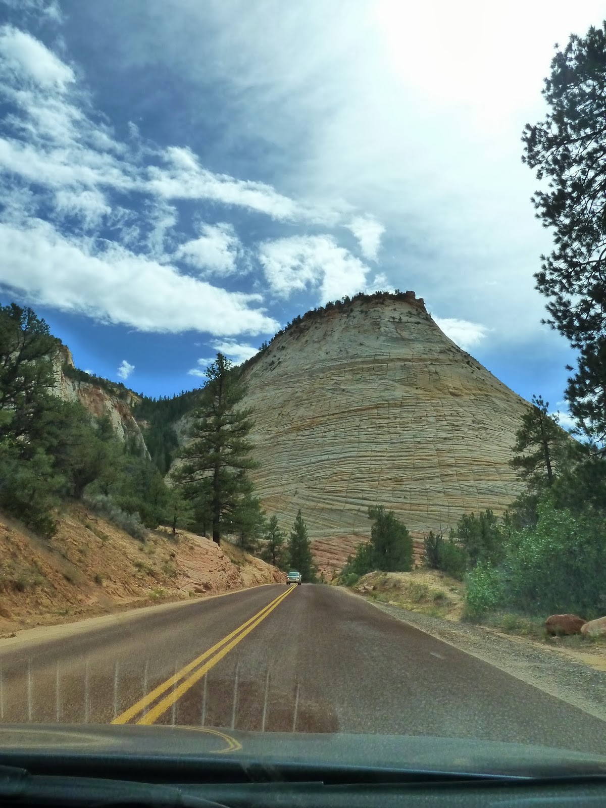
...as well as Checkerboard Mesa, named for the distinctive pattern eroded into it:

We hiked the Canyon Overlook trail. By the time we got to the viewpoint, it had started to rain, leaving the Altar of Sacrifice and other promontories shrouded in mist:

Zion is full of weeping walls and hanging gardens, where water that has been traveling through the rock seeps out and supports plant life. At this particular weeping wall I stopped to examine this small tree growing in a tiny crevice (Sarah for scale). My fingers fit into the crevice with little room to spare. It seemed impossible for a bird to land there, so how did the seed get there?

That afternoon we had planned on going for a dip in the Virgin River, but it had turned downright cold. We huddled in the car for a while, eventually falling asleep, then as the sun set we made a groggy effort to get down to the beach and sit in the white sand in our jeans and jackets, reading books.
That night it was cold and windy as we went to bed, but I woke up at 3AM to find the air had turned warm with no hint of a breeze. And then, when we woke up at 6 to hike, it was cold and windy again. We probably should have gone hiking at 3AM. We couldn't bring ourselves to get up before the sun was. We did have time before leaving to hike the Watchman Trail, from which we watched the moon set and the rays of the rising sun sweep over the rest of the park.


And it was time to go.
On the plane ride back, we happened to be seated so as to have a view of the park.

This allowed us to see, from behind, the very peaks (the Tower of the Virgin, the Sundial, and the Altar of Sacrifice, among others) that were visible on our hike and that can be seen above in the picture where Sarah is silhouetted before them. Below, I have circled the approximate spot where I stood to take that photo, and drawn lines indicating our view.

We also got to see the Narrows:

...and many other interesting things, including this fascinating canyon that I had to look up when I got back home. I found it is Coyote Gulch, another beautiful canyon of southern Utah, which I would love to visit next. (Unfortunately, it's a wee bit more than an hour's drive from an affordable airport.)

And below is Monument Valley, which I have driven past a couple times, in the upper-right (remind yourself of what Monument Valley is here):


And we had to come home. Back to work and chores and traffic. But it was an adventure we will always remember, and anyway, we will be having more!
No comments:
Post a Comment